Combatting the Urban Heat Island Effect with Drone-Based Thermal Imaging
At SmithGroup we are exploring the new frontier of UAV (drone) data to evaluate built environments for heat island impacts while discovering ways to help cities better adapt to climate change. Keenan Gibbons, a landscape architect and urban designer, is helping the firm lead this charge. An FAA-certified Remote Pilot, Keenan was awarded a firm Exploration Grant and summarized his research and findings in this five-part series.
PART 1 - UNDERSTANDING THE URBAN HEAT ISLAND EFFECT
Cities around the globe continue to become larger, hotter and more congested. On a warm summer day we have all felt the difference between a sweltering hot parking lot versus the forgiving shade of a tree. This is an example of the urban heat island effect. (Delete second paragraph) The urban heat island first gained notoriety after 30,000 deaths were attributed to the 2003 European heat wave, 14,000 of which occurred in France, putting the international research spotlight on Paris.
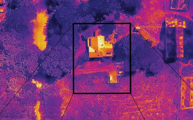
PART 2 - CAPTURING THE URBAN LANDSCAPE
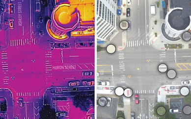
In Part 1 of this series we documented the severity of the urban heat island effect, outlined the streetscape pilot project conducted by SmithGroup for the thermal UAV study that is central to this story, and shared interesting results from preliminary training. In Part 2, we will cover how the urban canyon was successfully captured from the sky.
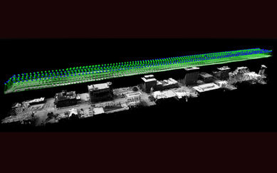
PART 3 - SCULPTING URBAN HEAT ISLAND IMAGERY
In Part 2 of this series we identified the extensive agency coordination required to successfully stage and implement urban UAV missions, then outlined the technical post-processing platforms that began to reveal a vivid glimpse of the reality of the urban heat island effect. In Part 3 we will sculpt the ‘shape’ of a day in the urban heat island effect.
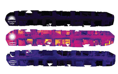
PART 4 - ANALYZING SURFACE AREA AND PHYSICAL SCALE
In Part 3 of this series we temporally sculpted the ‘shape’ of a day in the urban heat island effect. In Part 4 we breakdown the surface area and physical scale of the urban heat island effect.
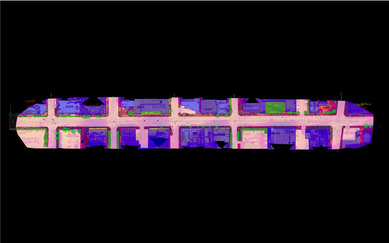
PART 5 - COMBATTING THE URBAN HEAT ISLAND EFFECT WITH UAV THERMAL IMAGING
In Part 4 of this series we sculpted the temporal ‘shape’ of a day in the urban heat island effect. In Part 5 we dissect and inventory the thermal material palette of the urban environment.